
The Smith House or Sidman’s Tavern along Route 17 in the Ramapo Pass is an important New York and Sloatsburg historical asset that also has a plot of pre-Revolutionary War Cemetery and last vestiges of the Clove Road, or Revolutionary War Highway.
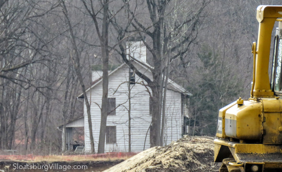
It was mid-May last year when the chainsaws bit the air in a flurry of activity at the site fast-becoming Ramapo Woodmont Apartments. The massive apartment development along Route 17 just south of Sloatsburg, NY, is located at the former, longtime home base of the Ramapo Land Company, and, as an historical note, is the last bit of a land tract that dates back to the very beginning of what is now Sloatsburg.
Trees were cleared, earth was moved and the huge excavated area, which for many years was sloping woodland and nearly hidden from view, was suddenly exposed brown dirt, complete with those familiar Rockland County boulders.
The Town of Ramapo Planning Board approved Woodmont in 2014, the waning days of Christopher St. Lawrence long run as town supervisor. The Village of Sloatsburg battled the development throughout the planning board process and, even after approval, into Supreme Court in Rockland County. The Village lost an Article 78 decision in 2015 but was able to stall the proposed project until construction finally broke ground.
With the removal of the thick tree coverage, the old white Smith House has been left standing like some lonely sentinel left over from a bygone era. It is known more recently as the former home of the Pierson Mapes family. But it’s history goes way back to the very beginnings of what would become Sloatsburg.
Before Stephen Sloat married Martha Van Dusen and built the Sloat House in or around 1753-55, there was the Van Dusen Tavern. Built by Issac Van Dusen possibly around 1714, the origins of the old house and tavern remain in the foundation stones, timbers and walls of the Smith House, or as it was widely known in its time — Sidman’s Tavern.
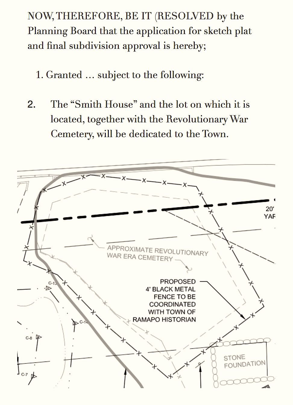 Part of Ramapo’s 2014 Planning Board agreement with Woodmont Properties, the New Jersey developer building Ramapo Woodmont, calls for the dedication to the Town of the Smith House (historically known as Sidman’s Tavern), a pre-Revolutionary War Cemetery next door and the last vestiges of the old Clove Road or Albany Highway. The Clove Road ran north/south to the west of the Smith House and parallel to what is now Route 17.
The Albany Post Road was the Colonial and Revolutionary War north/south land route from lower New York to Albany. The road followed the Ramapo River Valley through the Ramapo Mountains. The Ramapo Pass, also known at the Clove (from the Dutch kloof, which means chasm or gap), was strategically defendable at the bottleneck in Hillburn, NY.
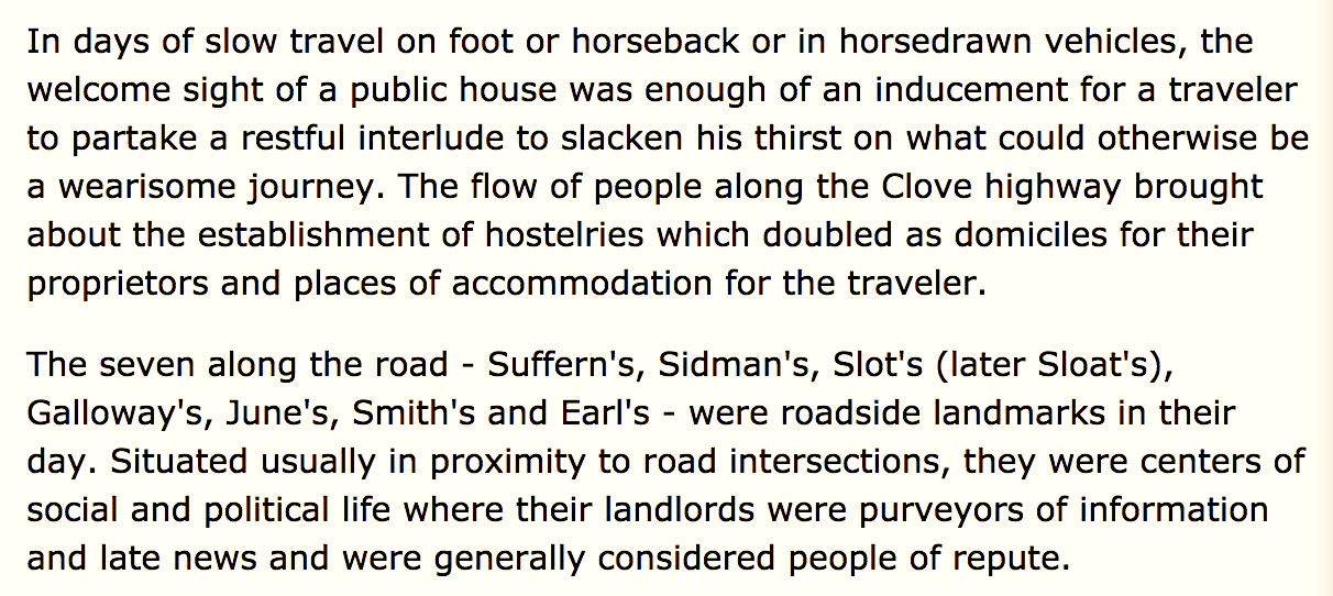
During the pre and post Revolutionary War period, the Albany Highway was a main route and circled from the Hudson River through these parts and then north, curling to Albany. People riding through the Clove Road only had a few public houses to spend a safe night.
Taken together, these historical assets provide the origination story of Sloatsburg.
 The dedication to the Town has put Ramapo and Woodmont into a predicament as Ramapo has been trying to reduce it’s historical property portfolio, leaving Woodmont in a sort of limbo about what to do with the Smith House/Sidman’s Tavern.
Woodmont Properties General Counsel Stephen Santola has said that Woodmont intends to preserve the Revolutionary War Cemetery. The Woodmont plans also calls for an historical marker to acknowledge the Albany Highway/Clove Road — with eventual input and oversight of the project by the Town of Ramapo Historian (currently Craig Long).
But both Ramapo and Woodmont are uncertain just what to do with the dilapidated Sidman’s Tavern, which has stood empty now for nearly 20 years.
The Historical Society of Rockland County and a contingent of Sloatsburgers prefer that the house be preserved and rehabilitated. Taken together the house, cemetery and vestiges of New York’s original highway provide a unique trifecta of historical assets for this area — and imbue the Ramapo Woodmont Apartments with a certain significance. Some wonder why the house can’t be restored during the building phase of Woodmont and then used by the property as a sort of public space.
Sloatsburg’s Original Land Grant: The Ramapo Clove
According to historical records documented by Corridor Through the Mountain by Richard Koke (written for the Orange County Historical Society), Isaac Van Deusen (also spelled Van Deursen and/or Van Duzen) came to the Ramapo Clove in 1724 with his father and settled on land purchased from the local Indians by John Van Blarcum. Clove is a Dutch word for a narrow valley with steep hills surrounding it.
Van Deusen land in the Ramapo Pass consisted of two main tracts that, together, shaped the Ramapo Valley and Sloatsburg. The northern “Pothat” tract was purchased from local Indians in 1738 by Dutch settler and Isaac Van Deusen brother-in-law, Wynant Van Gelder, and the southern tract, purchased from Van Blarcum.
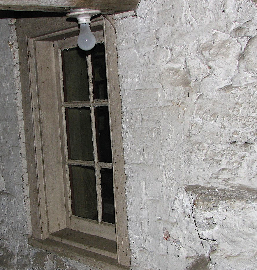
Part of the original stone and timber foundation of Sidman’s Tavern which could date back to the early 1700s.
In 1747, Van Gelder deeded the Pothat tract to Van Deusen and it was this tract that was deeded to Stephen Sloat in 1763 when he married Marretje Van Deusen, daughter of Isaac Van Deusen — the marriage apparently took place in the mid 1750s. These Sloat lands eventually became the Village of Sloatsburg and ranged from the current boundary line of Sloatsburg at the Orange/Rockland County line in the north to the Sloatsburg village line in the south near Auntie El’s. The tract ran from where the New York Thruway now snakes all the way west to Sterling Mine Road, and had the Ramapo River running through the middle.
Excerpt from Richard J. Koke’s Corridor Through the Mountains
Smith’s Clove: Wartime Line of Communication and Passageway for the Continental Army, 1776-1783. Published and copyrighted by the Orange County Historical Society.
English born Samuel Sidman entered the Ramapo Clove in 1746 and shortly thereafter married Isaak Van Deusen’s daughter Angneitje Van Deusen — making Stephen Sloat his eventual brother-in-law. Stephen Sloat went on to build Sloat’s Tavern, probably in the 1750s — the rear part still stands as part of the Sloat House & Inn and the entire house is listed on the National Register of Historic Places.
Sidman’s wife Angneitje Van Deusen was born at her father’s tavern in 1724 — which would make the Smith House or Sidman’s Tavern the oldest commercial and residential structure in these parts, and one of the oldest in Ramapo. Sidman and Angneitic inherited the tavern and lands south of the Pothat/Sloat tract in the Ramapo Valley which included all the land that is now known as Torne Valley.
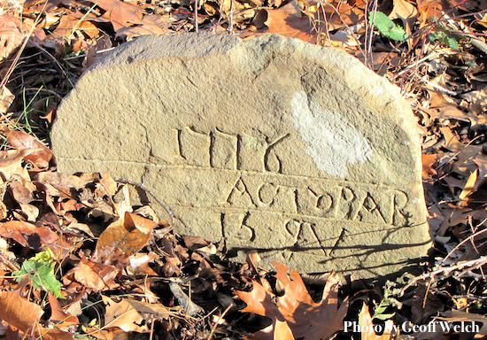
A cemetery stone found at the Revolutionary War Cemetery next to Sidman’s Tavern or the Smith House at the current Ramapo Woodmont Apartment development.
Both Sidman’s Tavern and Sloat’s Tavern, a mere mile north of Sidman’s, were two of the original seven Revolutionary War taverns above the New Jersey line on the Clove Road, that also included John Suffern’s Tavern.
Of the seven original taverns along the Clove Road, Sidman’s and the Sloat Tavern (now known as the Sloat House & Inn) may be the sole remaining structures from the pre-Revolutionary War period.
Sidman and John Suffern were signatures in 1775 of the General Association which pledged support of the Continental Congress.
The cemetery beside Sidman’s Tavern dates to before the American Revolution and is the known burial plot for the Van Deuser family, including Samuel Sidman who died in late 1777 or 1778. Significantly, the cemetery beside Sidman’s Tavern was likely used to bury members of the Colonial army who died while guarding the Ramapo Pass.
Woodmont and Ramapo and Historical Preservation
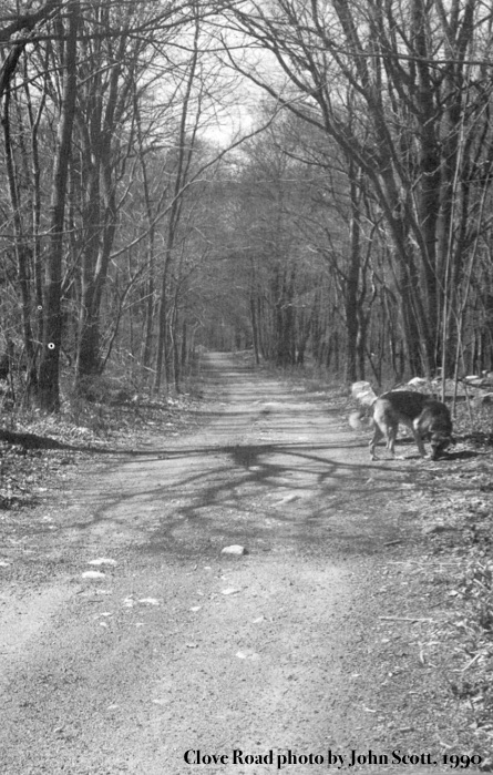
A photograph of the old Clove Road, a remnant of the original New York and Albany Post Road, also known as the Revolutionary War Highway, which ran through Rockland County and, significantly, the Village of Sloatsburg. Parts of Clove Road road in this area of Orange and Rockland Counties eventually became Orange Turnpike/Route 17.
To date, the fate of the Smith House is undecided. Woodmont awaits Ramapo’s direction and Ramapo possibly awaits whether preservation is worth the effort.
The Smith House at Ramapo Woodmont is part of the story of Sloatsburg. As importantly, the three assets are nationally significant and their preservation would celebrate the character and culture of the Village of Sloatsburg, Hudson Valley and New York State, especially as the nation prepares to mark the 250th anniversary of the American Revolution.
